Landing a GIS Job and GIS Skills Development in 2013

Good Read

John Donoghue

Note: This post is a 2013 update to my earlier post on Learning GIS and Getting a GIS Job – Some Tips and Tricks which was originally posted in 2009.

In 2009 I wrote a post on how to obtain a GIS job that focused on pathways to learn GIS, critical skills every GIS analyst should know and ways to augment traditional learning pathways to set you apart from other job candidates. Even though this post is well over 3 years old, it’s still read by people interested in the topic and I still receive comments.

I recently re-read the post and decided that an update was in order. Software has changed and old skills need to be replaced with new skills to keep up with the evolving GIS software industry. For brevity, I’ve focused this new post on changes and revisions to the recommendations I made in my earlier post

View original post 3,610 more words

Diploma Sains Geomatik ( Sistem Maklumat Geografi)

So yeay, new school, new environment, new friends, hostel, etc.

Turned out that bracket with”Sistem Maklumat Geografi” I was exited about in the Diploma name is well, just a bracket.

Coming from a family background with no expose of surveying, I didn’t know you had to learn how to survey A LOT. I had to go out under the sun, engineering survey, solar observation, u name it.First time using the theodolites/ total stations, setting up the instrument on tripod, getting skin all tanned, etc.

Fasting month together with outdoor survey work was the bomb. It was quite an experience indeed! Tired but worth it.

A little bit of the computer using CAD -drawing plans. You will only start learning GIS after 1 1/2 years of surveying. Surveying was fun to learn, although I liked being outdoors instead of classrooms and all, but it wasn’t really my thing.

After all, i’m glad i have learned the subjects of surveying, I get to have all of the basics and understanding for necessary ground processes before finally have everything in the information system like a GIS! I find it to be a crucial thing to know because it’s all about positioning, datum, projection, boundaries, etc we need to know about.

survey

( Image Source from http://www.survey4u.com/)

That’s a picture of people surveying up there, one with the instrument and the other one who’s holding the pole. Surveying come in many form that’s one of ’em.

Now here is one of the pictures i found of GIS:

challengetask12


and these are the definitions of GIS i compiled:

a)    GIS is a computer system for capturing, storing, query-ing, analysing, and displaying geospatial data (Chang, 2012).

 b)    GIS is an integrated collection of computer software and data used to view and manage information about geographic places, analyse spatial relationships, and model spatial processes. A GIS provides a framework for gathering and organizing spatial data and related information so that it can be displayed and analysed(Wade & Sommer, 2006)

 c)    A GIS integrates hardware, software, and data for capturing, managing, analysing, and displaying all forms of geographically referenced information(ESRI, 2012)

Till Then

Mah

Geomatics

I had no particular ambition when I was a kid, I wanted to be a doctor once though. But I guess it was every child’s dream to be a doctor. When I was in primary me and my good friend wished that after we have finished school we’d be doctors together, we had the same ambition at that one point. After I got into secondary I didn’t really want to be a doctor anymore, neither did I have anything else i wanted to be in mind. I did get into Science Stream like everyone else.

(Oh, still friends with her, and she’s studying Masscomm now. I didn’t do well enough in my SPM to be a doctor anyway.)

When i was filling up my UPU after SPM, that was the first time I learned about GIS and Geomatics. Okay I didn’t know what I wanted to become, I was in a dilemma on choosing which course to take after SPM. I didn’t have much choices though, everyone else with a better results will get in easier. I went through all of the public universities’ list of courses. Pretty sad because I didn’t do well enough in my SPM.

I had no interest at all in doing anything like Business or Accounting, and all those stuff related to it. One is because it’s too common and two because everyone else is doing it. It’s a good course no doubt! but I just prefer to avoid those.

Diploma Sains Geomatik ( Sistem Maklumat Geografi).. I wondered what it was all about.

Geomatics… What’s Geomatics? I can’t find the word geomatic in the dictionary when I first came across the word geomatic, or Geomatik in Bahasa. And it is even annoying to have the Auto spelling have my word Geomatic underlined.

So I googled Geomatic. And it got me into Wikipedia. And so i read and read and skimmed through some webpages i found. Interesting! Especially on the applications of Geomatics.

Next i was curious what Sistem Maklumat Geografi/GIS was. It brought me to Wikipedia and some other websites as well. Turned out GIS  was even interesting to read and to find out what it was all about!

Cool thing about it was that, I’ve always liked the computer. I grew up watching the technologies getting so advanced day by day, and my siblings playing computer games and we also had an internet dialed-up connection. Oh how I’ve missed the sound of a dialed up connection and my dad or sister who got angry every time they wanted to use the telephone and would ask the person ( usually my brother) using internet to stop using the internet for a while because the telephone line can’t be used when the internet is connected.

I also like maps as well. Diploma Sains Geomatik ( Sistem Maklumat Geografi) was just a perfect combination! It was so aawwwesome that I would be learning new software like GIS and will be using the computer most of the time! or so i thought.

I got into Diploma Sains Geomatik ( Sistem Maklumat Geografi) Alhamdullillah and it was my first choice, ( And also thanks to somebody).

And so my journey and interest towards Geospatial Technologies Began………

Geospatial

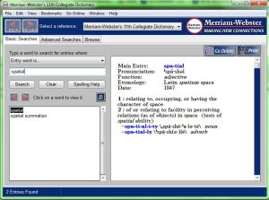
What is geospatial? I have first heard of the word spatial back in school, probably in 2008/2009. Every time I encounter words that I do not know, i would usually search them in the Merriam Webster dictionary I have installed in my computer. I also have Oxford now.

Merriam Webster

spatial_oxford

Well according to one of the dictionaries above, spatial is something relating to, occupying, or having the character of space/ of or relating to facility in perceiving relations (as of objects) in space.  It is pronounced similarly to how you’d pronounce SPECIAL. But my lecturers or classmates and friends would mostly pronounced it as “SPUH-TIAL”. I’ve checked in the oxford dictionary as well, and it is both pronounced as “special” in British and American.

I really like the sound of it. Hence I’ve come up with the blog name specialspatial, because it rhymes! And also because Spatial really  is special!

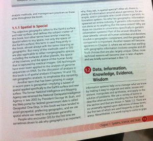
Another reason how i came up with the blog name because i read it in a book, there’s a sub section named Spatial is special. This is the book:

gis

And here is a pic i took of the book section:

Spatial is Special

Now you may ask what Geospatial is, I’ve tried searching in both Merriam and Oxford, both have no definition of it.. But,,,, According to the book above, “geospatial implies a subset of spatial, which is applied specifically to the Earth’s surface and near surface. From my point of view, it is a combination of Geographic + Spatial = Geospatial.

Anyway that’s a good book.

Till next time!

Mah

Hello All

Hi!  This is my first blog post. I will share and mainly talk about geospatial activities that I have interest for. It could be about the geospatial revolutions, the advanced technologies we have now, software, tutorial, thoughts, sharing links and videos and many more (hopefully!)…

I am in my 20s, I have recently completed my bachelor’s degree in Surveying Science and Geomatics in UiTM Shah Alam.  I have no good background of writing, this platform will be used for me to improve my writing, my English, my Bahasa Melayu, my vocabulary, my knowledge, and also for me to share about anything geospatial ..or anything else. I will not get too personal about myself and who I am, and I would also prefer to be Anonymous, just contact me personally to know more about me!  For now, just call me Mah…

Till next time

Mah